|
Planning cycling trips with a map is as enjoyable as doing the cycle itself. I spend hours staring at my map of Scotland. I look for roads that I have never cycled on. I wonder what it is like to be on those roads and what the scenery is like. I go into a dream world of undiscovered parts of Scotland, new things to see and new people to meet. I can travel in my imagination and have an adventure without even being there. Sometimes when I go to bed I choose to look at my map instead of reading a book. I get so excited about the roads and where they can take me on my bicycle. I stare at the map until I can no longer prevent my eyelids winning their battle to close over. Sometimes I wake up in the morning and the map is still resting on my lap. My joy of maps was shared by the travel writer and explorer Rosita Forbes (1890-1967). Her eloquent quote makes me tingle with excitement because it so perfectly captures those feelings of wonder when looking at a map: “That is the charm of a map.It represents the other side of the horizon where everything is possible. It has the magic of anticipation without the toil and sweat of realizations.The greatest romance ever written pales before the possibilities of adventure that lie in the faint blue trails from sea to sea. The perfect journey is never finished, the goal is always just right across the next river, round the shoulder of the next mountain. There is always one more track to follow, one more mirage to explore. Achievement is the price which the wanderer pays for the right to venture.” “…the magic of anticipation without the toil and sweat of realizations.” This is very true! Looking at a map it is virtually impossible to discern what it is really like to be there. I can form a romantic picture in my head that does not always take account of punctures, torrential rain, killer hills and other “toil” that a cyclist can face. I am particularly attracted to the “white” roads on the map. The roads that do not have a letter and number designation. The “nothing” roads. Many of these roads appear to serve no practical use for the average car driver as they serve no place of sizeable population. In fact, it almost seems that these roads were put there for the purpose of cyclists to enjoy the countryside. Scotland has plenty of such roads and I came across the ultimate “nothing” road when spending one of my evenings staring at the map. I was following the Far North railway line looking for train stations that serviced isolated roads. I came across Altnabreac station in Caithness and a big grin appeared on my face when I saw the single “white” road travelling from the station into nowhere. There was only one place marked on the road- Dalnawillan Lodge. Nothing else until the road emerged out of the wilderness and eventually connected with routes heading to Wick. I had to go there! There was every possibility that I could have this road all to myself. I discovered that Altnabreac train station is the 8th least used in Britain. I found out that the one place the road seemed to serve- Dalnawillan Lodge- was closed down. It had been a Victorian hunting lodge, but is now boarded up. I managed to find a photo of this abandoned lodge and this conjured up pictures of once grand banquets after shooting parties in the wilderness.  Dalnawillan Lodge. Photo from Inverness Courier I booked my train tickets and talked excitedly to friends and family about this fabulous road I had seen on a map. I think some thought I was crazy to be this enthusiastic about a road. It’s just a road, big deal! But they didn’t get it. In a world where almost everywhere has been explored there is little opportunity to capture that feeling of being the first there, or one of few who have been there. Finding that road on my map captured that excitement of the undiscovered and the opportunity to feel what Rosita Forbes felt.
A final word I was going to include a Google map of this road, but it does not look nearly as exciting as it does on a paper map. You really need to be able to see the road in relation to the surroundings and remoteness of the area and this is much better seen on a full page road atlas. It is even better if it is a used map and has some smears, watermarks and folds like mine does now. The map came with me to Altnabreac and these marks are the story of our journey. I plan to write about my experiences on this road and post it on the website. In the meantime have a look at Altnabreac the next time you pick up a road atlas. You might just feel the same excitement.
11 Comments
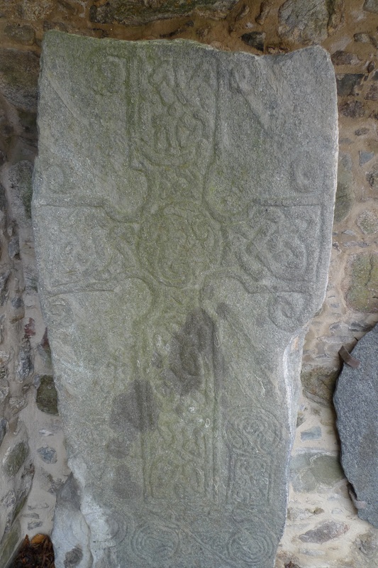
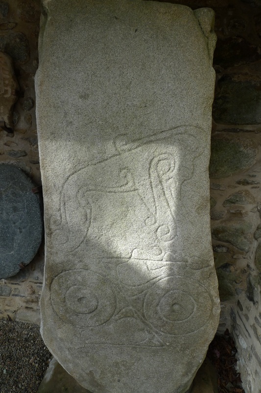
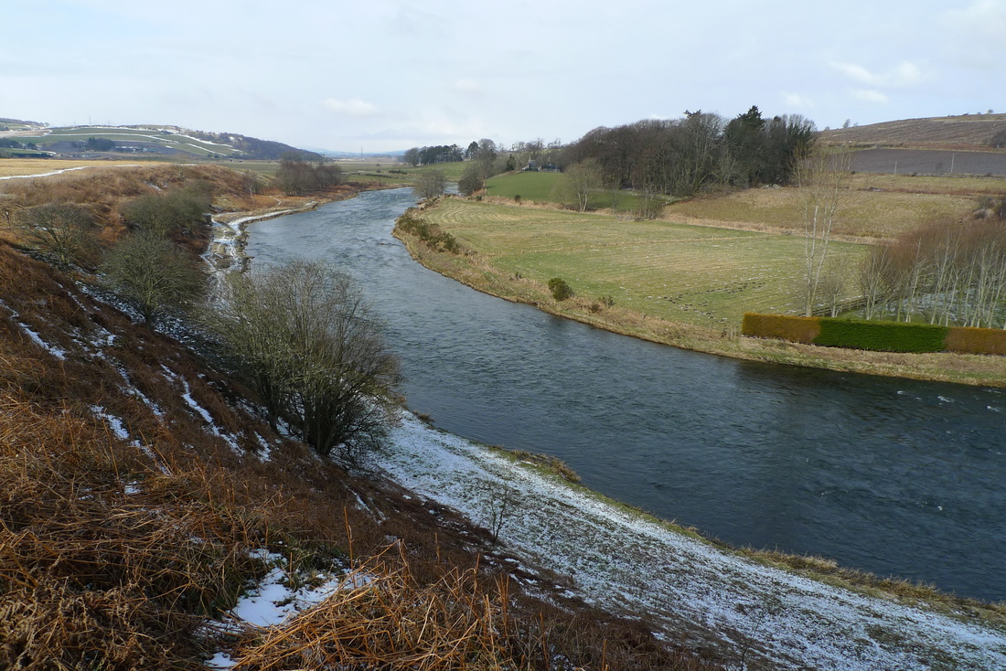
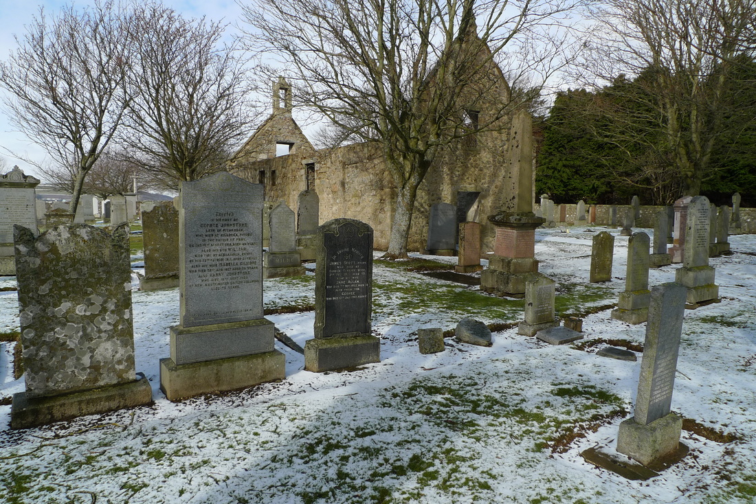
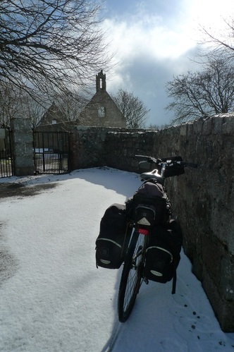
Problems on the railways ruin my plans, but divert me to sixth century standing stones in the snow. At Aberdeen station disaster struck. I tried to board my train to Inverurie and could not get on. People were squeezed up to the doors and stared back at me and my fully loaded bicycle, most probably thinking, “no chance!” I did the walk of shame back down the length of train, aware of being watched from the packed carriages. “I’ll get the next one!” I called out cheerily to the guard standing on the platform, trying to hide my disappointment and embarrassment. “Trespasser mate. On the line between Dyce and Inverurie. The train before was cancelled, like. They’re all piled onto this one now. Don’t know when we’ll get away. “ The guard delivered this information with a cheery voice and a smile as if telling his mates down the pub that his team had just won the match. He really didn’t seem bothered by it all and it made me determined to show him that I was equally relaxed about it. However, when I was told that the next train to Inverurie was not scheduled for over one and a half hours I could feel the annoyance bubbling inside my stomach. This was seriously going to ruin the cycling trip I had planned. I had a look at the departures board, just in case there was another option. There was a train to Dyce due in about 15 minutes. Was that of any use? I got out my map to see how possible it was to cycle from Dyce to Inverurie.  Aberdeen train station I needed a route that avoided busy roads and motorways otherwise it was not an option.Yes! There it was, a route using mostly a minor road and some B roads. It was going to add another 15 miles to the trip, but it was better than standing about waiting for the next train to Inverurie that could also be delayed. I got on the train to Dyce and felt proud that I had managed to conjure up a plan B and rescue my trip. I didn’t really want to have to cycle between Dyce and Inverurie, but I looked upon it as a little adventure. When the ticket collector came round I explained why I had a ticket to Inverurie on a train that only went as far as Dyce, “I am going to try to cycle from Dyce to Inverurie.” She gave me that ‘are you mad’ look as we passed through a snowy landscape. The train only takes about ten minutes from Aberdeen to Dyce and I was soon cycling along roads that were not much fun. Dyce is where Aberdeen airport is located and there are a lot of office complexes and industrial units on the outskirts. This results in considerable traffic, some of which is articulated lorries that made me wince when they trundled past. I began to wonder if the coffee shop at Aberdeen station for a one and a half hour wait might have been preferable, but luckily it was not long until I reached the turn-off to the minor roads that would take me to Inverurie. 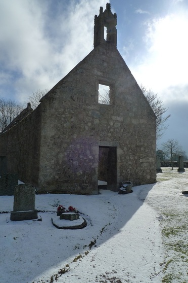 Chapel of Saint Fergus. The stones are inside Soon after leaving the roaring lorries behind me there was a sign, “Dyce Symbol Stones.” It pointed away from my route, but I was curious so I went to investigate. The road was fresh with snow and no tyre tracks, so I was the first on it this morning. It climbed to a spot overlooking a curve in the River Don, the sixth longest river in Scotland. There was a ruined chapel and churchyard with untouched snow leading to the gate. My tyre tracks the only evidence of activity. Inside the chapel are two standing stones, one on either side of the doorway. The oldest of the stones dates from the 6th century and has some sort of beast and Pictish symbols carved into it. These symbols remain a mystery with no definitive answer as to their meaning. The other stone has an easier carving to understand- a cross.
The Picts were a group of people who lived in eastern and northern Scotland during the Late Iron Age and early Middle Ages. This region of Scotland has an abundance of Pictish stones and they mostly sit in natural surroundings, often exposed to the elements. The chances are high that you will be the only person at the time of your visit and you will have silence and space to appreciate the stones and perhaps come up with your own theories about the meanings of the carvings. Utter peace and quiet is what I experienced in this place. Only minutes away there were busy roads, noise and industry, but in this spot there was solitude. I really wanted to stay longer, perhaps sit down for half an hour and empty my head, but I had to push on and get to Inverurie. Even on a cycling trip time is precious. If it was not for a delayed train I would never have discovered this place, so it was one of those rare occasions that I was happy to be a victim of a public transport disaster.
Getting there
Dyce is a 10 minute train journey from Aberdeen. Aberdeen can be reached by train from Edinburgh in around 2 hours 20 minutes. From London journey time to Aberdeen is around 7 to 8 hours. The Dyce Symbol Stones are a 2.2 mile cycle from Dyce train station. The route is shown on the map. Leave the station on Station Road which takes you to a crossroads. Turn left onto Victoria Street. Then take the second road on the left- Pitmedden Road. Parts of Pitmedden Road can be busy with traffic, but at these points the road is wide enough for safe passing. Follow this road until you see the sign for the Symbol Stones which involves a right turn and crossing a bridge over the railway. There is an old pillbox guarding the bridge. Take this road until the churchyard comes into view. Dyce is also the starting point of the Formartine and Buchan Way, a cycle and walking path over a disused railway line. This goes all the way to Fraserburgh and Peterhead. You can read about my cycle on this route in Riding the rails. You could combine a visit to the Dyce Symbol Stones with a cycle on the Formartine and Buchan Way. 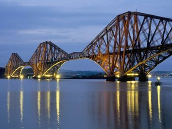
The Forth Railway Bridge. Photo from thechatterjis.wordpress.com
The Forth Railway Bridge is one of the most famous bridges in the world and is one of the symbols of Scotland. I am lucky enough to be able to cycle to it whenever I want as it is just 13 miles from the centre of Edinburgh. During a Monday afternoon in the office I suddenly realised that within hours of leaving my desk and computer I would be cycling across the Forth Road Bridge. A friend had invited me to cycle home with him and part of the route took us across the bridge. I was feeling a bit tired during work and was half wondering if I should cancel and do the usual Monday activity of lying out on the sofa. However, I started to feel that tinge of excitement that comes on when I am soon to embark on a cycle run. This particularl run was even more special because of the bridge. Could there be a better way to spend a Monday night after work? The cycle route to the bridge is mostly traffic-free and on quiet roads. It leaves Edinburgh on disused railway lines. Near Crammond I noticed a roaring fire through the window of a stone cottage. There were plenty of daffodils, crocuses and snowdrops along the way. The early evening sun was strong and low. 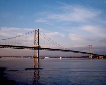
Forth Road Bridge. Photo from www.edinburgharchitecture.co.uk
There is a separate cycleway and walkway on the Forth Road Bridge. What amazes me is that the bridge is one of the hilliest points of the route. I would expect a bridge to be flat, but not this bridge. It goes up and up to the middle and then down again. If the wind is against you this can make it a very slow and tough cycle, but tonight the wind was behind us and we flew across. The bridge is 2.5km long so it felt like we were on it for ages, but this was no bad thing because it was more time to admire the neighbouring railway bridge. The Forth Railway Bridge opened in 1890 and took 7 years to complete. I watched a train make its way across and it was completely dwarfed by the massiveness of the structure. It is 8,000ft long, the towers are 361ft tall and it is made from 53,000 tons of steel. 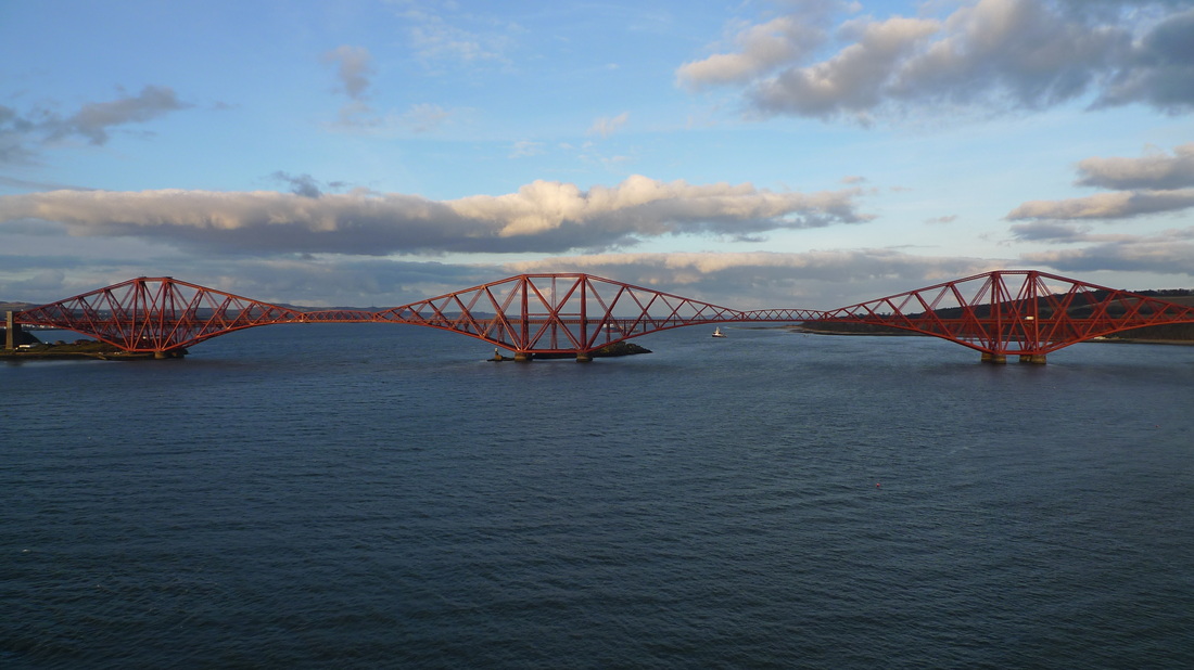
My view of the Forth Railway Bridge whilst cycling across the Forth Road Bridge
The view behind us was equally impressive with the snow covered Pentland Hills. 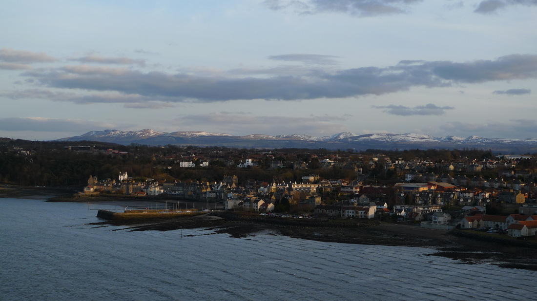
South Queensferry with the snow covered Pentland Hills in the background
My friend lives in Aberdour so we continued our cycle to his house. After a good chat over coffee and a home cooked meal I went to catch the train back to Edinburgh. Aberdour train station has to be one of the best cared for in Scotland. It has its own greenhouses where the colourful plants that adorn the platforms are reared. I was home for bedtime and was so glad that I had spent my evening this way. It made me appreciate how lucky I am to live somewhere that you can jump on your bike after work and end up somewhere amazing, even iconic. 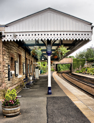
Aberdour train station. Photo from flikr.com
This book follows the cycling journey of a retired man from Leicestershire. He travels from the Mull of Kintyre to Cape Wrath in Scotland. I read the book to see what other cyclists have written about Scotland and to see if my own travel writing is any good compared to other authors. It was also a part of the country I am familiar with and would enjoy reading about. The journey is done at an average of 4.5mph and covering a daily average distance of 38.5 miles, so this is not extreme cycle touring by any means. This is not for readers looking for a tale of high adventure, record distances and time pressures. Richard Guise uses his sense of humour to take the reader on this journey through a beautiful part of Scotland. He had me laughing with his descriptions of some of the things that cyclists encounter like bad weather, the search for good coffee and the habits of sheep."Now, if they couldn't even distinguish their mother (white, wooly, four legs) from a man on a bike (yellow and black, two wheels) then I didn't much rate their chances of surviving even long enough to provide a decent Sunday lunch." I was not so keen on his descriptions of local people. Whenever he quoted their speech it was like a bad Scottish stereotype, "Och well, Hamish, a dram on the house all the same?" He describes Lochinver as being populated by "barking dogs, wailing children and overweight mothers." He encounters many Eastern Europeans working in the hotels, restaurants and cafes along the route that he describes as 'Easties.' It comes across as ignorant and racist. He has not written about any meaningful encounter with local people where he had learned something about the area and their lives.. There are little information boxes that inform the reader about the history of the area that are easy to read and not dry, with Guise using his humour to lighten up the history. There is also a nice section in the middle of the book with colour photos. Guise does give a great impression of the freedom, empty roads and peace and quiet on this route, "For me, among all the positive attributes of most Highland settlements I passed through, this is the most endearing: that between, say, 7.30pm and 7.30am there's almost nothing on the main road through town. There's nowhere else to go, you see, and anyone who's coming is already here. Priceless." I found his descriptions of the scenery average and not quite capturing just how special this part of Scotland is. I do sympathise- it is difficult to describe landscapes without resorting to the clichés of 'beautiful', 'spectacular' and 'magnificent'. However, all good travel writers should be able to entrance their readers. I am not sure how many readers will be inspired to cycle in Scotland as a result of this book. I do not feel that it does justice to the landscapes and people of the area. It might encourage people of a similar age to Mr Guise to give cycle touring a try. If you have already been to these places and fancy reading about another person's journey then you will find some interest in this book, but the sense of humour is not for everyone. |